Stronger Landscapes Plan
Supported by the Australian Government
SQ Landscapes acknowledges that First Nations of Southern Queensland have looked after natural assets for tens of thousands of years and that a combination of First Nat ion science and knowledge and other approaches can help make Country stronger.
Stronger Landscapes is an emergency preparedness and response plan for biodiversity and agricultural natural assets in Southern Queensland.
Emergency events including natural disasters like flood, fire and drought impact our lives, economy and the environment.
Please share your experiences and ideas of how we can work better together to prepare for and recover better from these events.
See what the Stronger Landscapes Plan is about and provide your thoughts using the button at the bottom of this page.
The Stronger Landscapes Plan will:
- build on the lessons learned from previous natural disasters
- consider the potential impacts on natural assets of future severe weather events and other threats such as new outbreaks of pests and disease
- not duplicate existing State and Local governments plans for protecting life, property and infrastructure.
The Stronger Landscapes Plan will aim to:
Biodiversity assets
Agricultural natural assets
The following map shows areas of Southern Queensland which have biodiversity and agricultural natural assets which are of national importance according to the features listed above.
How can we work better together to make the Biodiversity and Natural Assets of Southern Queensland stronger from the following impacts:
4 million ha of habitat is at risk from drought 400,000 ha is at risk from wildfire
45,000 ha of forestry is at risk from severe bushfire
1 million ha of cropping land is at risk from drought
Up to 5 million ha of significant plant communities is at risk from drought
31% of Main Range National Park is at risk from severe wildfire
150,000 ha (100%) of Currawinya Lakes National Park and Ramsar Wetlands is at risk from drought and new pest plants and animals and disease
14 million ha of grazing land is at risk from prolonged drought
GAB Springs are at risk from pests and excessive water use
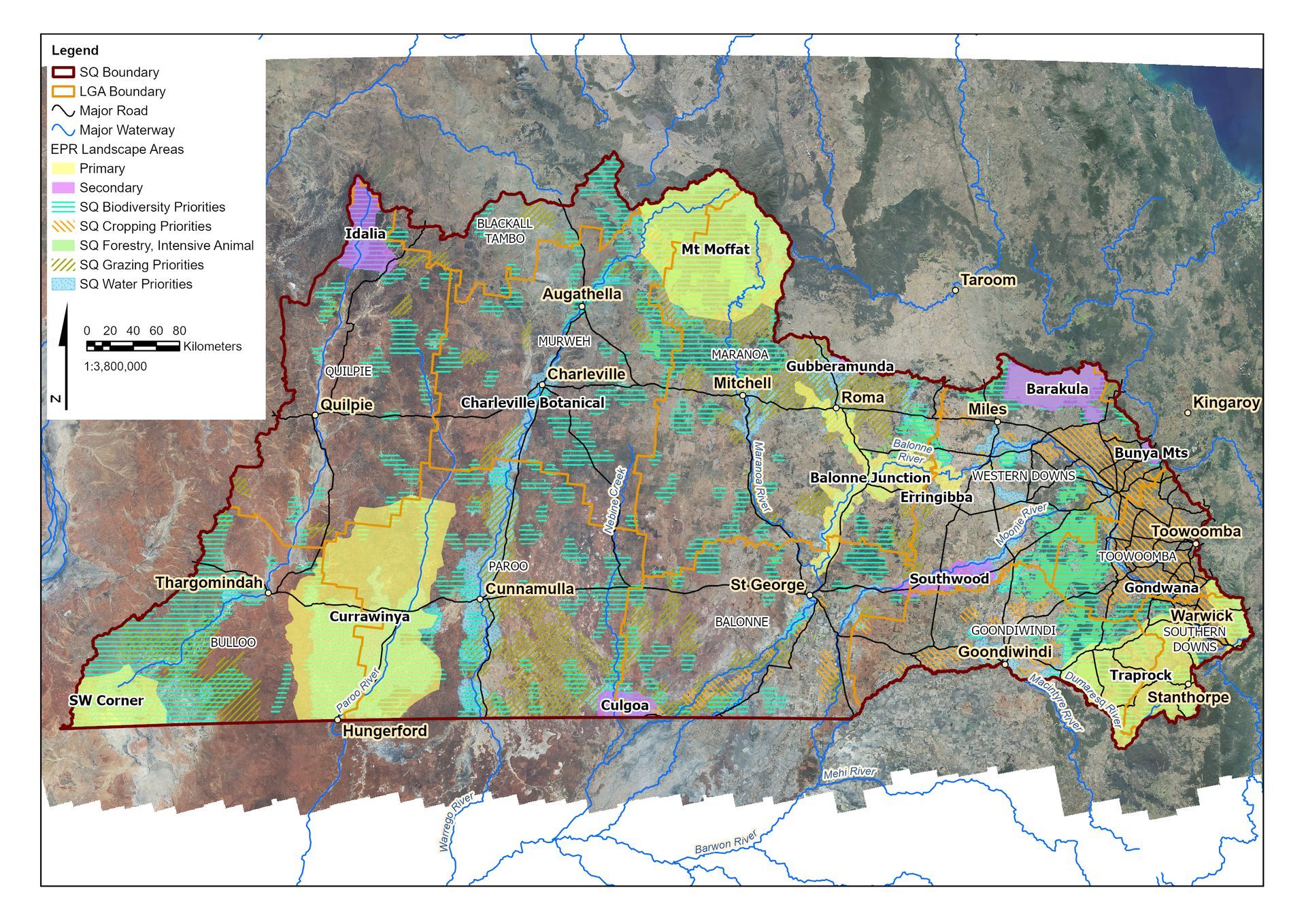
Based on your experiences and thoughts, how do we work together to address the following events on the areas shown in this map?
List of Services
List of Services
-
WindList Item 4List Item 4
Strong winds and storms can affect up to 19% of the area of natural assets in SQ.
-
CloudNew List Item
Increased localised flooding due to more isolated and intense rainfall events.
-
WeedNew List ItemNew List Item
Pest plants and animals including new outbreaks.
-
Plant
Impact of plant and animal diseases, especially new outbreaks.
Several organisations have developed and are implementing actions to better prepare and to respond to emergency events including:
Local Government and Emergency Services – Local Disaster Management Plans and Disaster Management Groups
Local Government and Biosecurity Queensland (Department of Agriculture and Forestry)
– Biosecurity Plans
Queensland Emergency Services – Rural Fire Brigades, State Emergency Services
Australian, State and Local Governments, First Nations, Landholders, Industry and Non Government Organisations:
- Preparedness and response planning and action for natural disasters
- Climate Smart Agriculture program (Australian Government)
- Threatened Species Plans and investment programs (Australian and Queensland Governments)
- Best Management Practices (Industry)
Other responses include:
- National Park Management Plans (Department of Environment Science and Innovation)
- Slow the Flow Program – rehydration of the floodplain and landscapes
- Great Artesian Basin Sustainability Initiative (GABSI) – capping bores and restoring bore drains
- Fire response and management including ecological (cool) burning – First Nation knowledge and science for caring for Country
- Vegetation management – shelter belts and connections.
How can the Stronger Landscapes Plan support these current responses to the predicted future impacts?
Stronger Landscapes for Healthy Communities
-
Assets of Southern Queensland
The Great Artesian Basin underpins $2 billion in economic activity annually and supports unique plants and animals
-
New List Item
Tourism worth $1.3 billion
-
New List Item
Plant Communities of National Environmental Significance – 27% of SQ
-
New List Item
Habitat for animals and plants of National Environmental Significance is likely in 36% of SQ
-
New List Item
Protected Areas and Nature Refuges - 7% of SQ
-
New List Item
Cropping worth $1.6 billion
-
New List Item
Cropping 2.5 million ha - 8% of SQ
-
New List Item
Main Range World Heritage Area
-
New List Item
Grazing on 26 million ha - 83% of the area of SQ
-
New List Item
Currawinya Ramsar Wetlands of International Significance
Related Projects
This project is funded by the Australian Government’s Natural Heritage Trust and delivered by Southern Queensland Landscapes, a member of the Commonwealth Regional Delivery Partners Panel